Neighbors Against Irresponsible Logging (NAIL)
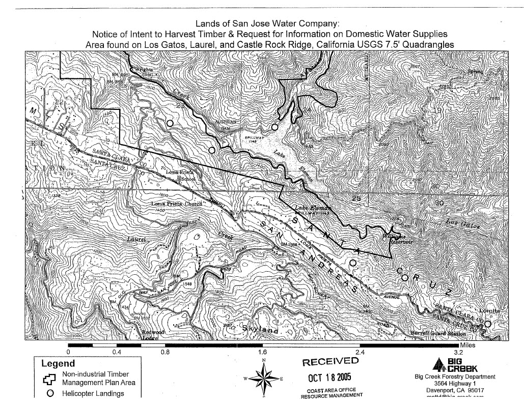
Neighbors Against Irresponsible Logging (NAIL) is a community group in California's Santa Cruz Mountains that formed after local residents received a legal notice in the mail about a proposed logging plan. The notice included the above black and white map which was prepared by a local logging firm and sent by the San Jose Water Company, which owns about 6,000 acres of watershed land in the region. The watershed provides drinking water to local residents as well as to over 100,000 Silicon Valley inhabitants. It also contains the county's largest remaining stand of coastal redwood forest.
 “
“The map sent to residents of the Santa Cruz Mountains neighborhood
”
Many residents were puzzled by the map, which offered no clear distinction between roads, topographic contour lines and the plan area. It was so difficult to understand that many people simply threw it away, but NAIL member Rebecca Moore thought that the community might better understand the potential issues if she remapped the key elements of the proposal on top of 3D high-resolution satellite imagery in Google Earth. The visualization that Rebecca created changed community and policymaker opinion about the logging plan and eventually helped to stop the plan completely.
How they did It
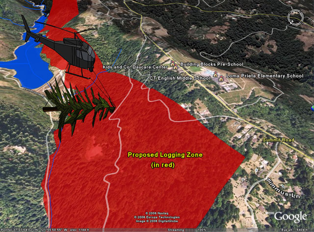
Rebecca Moore wanted the Google Earth visualization to be technically accurate, so she did not hand-draw the logging boundary in Google Earth. Instead, she obtained digital parcel data from the county planning department in “shapefile” format (.shp) and imported it into Google Earth using Google Earth Pro. With Google Earth, Rebecca edited the properties of the parcel shapes to color them a semi-transparent red. Adding placemarks, Rebecca designated plan elements such as the proposed helicopter landing pads near schools, daycare centers, and homes, as well as where mountain water companies drew drinking water from the creek. She also added geo-located photos of old-growth redwoods that could be cut and wildlife sightings, including osprey and beavers by editing the info window of the placemarks.
Finally, using the Add Path tool, Rebecca drew an invisible path up the Los Gatos Creek Canyon, from beginning to end of the proposed 6 mile, 1000+ acre logging zone. Using the Tour command on this path in Google Earth, users of the KML can easily sit back and take a virtual flight up the Los Gatos Creek canyon, which turns out to reveal a number of issues in the plan.
Rebecca authored this KML entirely from within the Google Earth client, by importing the parcel data and using simple tools, with no programming needed (the only exception was that she created a Screen Overlay of the NAIL bumper sticker, using simple KML). The creation of the KML took a single weekend.
At NAIL's first community meeting, Rebecca presented the virtual flight over the logging plan, illustrating the steep, narrow mountain roads that would be burdened with a dozen 90,000-pound logging trucks per day, navigating more than 30 blind curves where children walk to school. Viewers could even fly to the actual locations and see photos of old-growth redwoods that could be lost.
Watch a flyover of the logging proposal elements remapped in Google Earth.
I thought I was well-informed regarding SJWC's application to log the watershed above Lexington. But I nearly fell off my chair when I had a good look at Rebecca Moore's Google Earth presentation of the logging zone. This three-dimensional presentation gave an amazing topographic bird's eye view of how invasive the logging will be.
”Letter to the Editor, Mountain Network News, by resident Lisa Sgarlato
Impact
The flyover electrified the room. Suddenly everyone began to call out issues, questions and concerns. The community used Google Earth interactively to zoom to and study various areas. Rebecca was asked to repeat the flyover twice that day, and subsequently presented it at more than a dozen additional community meetings and to many individuals and organizations, such as California Assemblyman Ira Ruskin, the Santa Clara County Board of Supervisors, the San Jose Mercury News Editorial Board and Former Vice President Al Gore.
Community members requested that Rebecca post this KML so that they could use it to explore the plan. She also created a simplified movie version. Michael Ashbridge, a colleague on the Google Earth team, helped create a 3D SketchUp model of a helicopter hauling a redwood tree out of the canyon, on a realistic flight path near several schools. She imported data from the California Natural Diversity Database showing sightings in the Los Gatos Creek canyon of endangered California red-legged frogs, to challenge the plan's claim that no endangered species were present in the watershed.. Other community members contributed information and photos such as the one of NAIL's mascot, Charlie the Beaver, a "Responsible Logger".
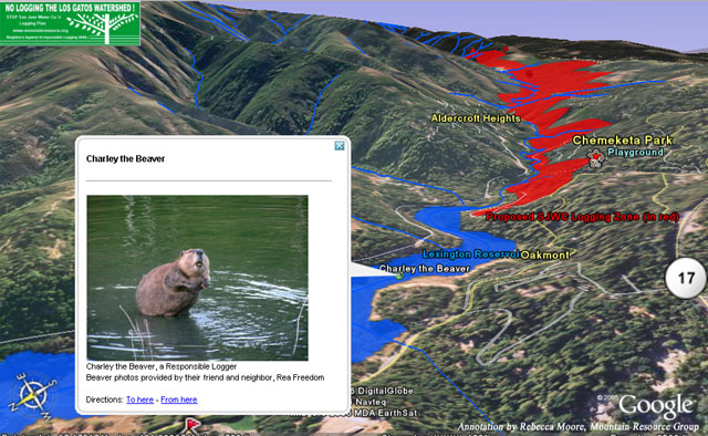 “
“NAIL's mascot, Charlie the Beaver, a "Responsible Logger"
”
Two years later, the California Department of Forestry ruled the logging plan ineligible. Rebecca's pioneering work was a victory for environmental advocacy, and also showed that Google Earth can increase public awareness of community issues and facilitate real social change.
Google Earth was instrumental in this grassroots victory, which also resulted from the hard work of many in the community. Google Earth succeeded in giving the community much more context for interpreting and evaluating the logging plan. Potential issues of the plan related to proximity, topography, natural and human-made features could only be grasped by viewing the plan against real-world imagery and 3D terrain. As a result of this and other research, NAIL was able to articulate clearly-identified problem areas in the plan, such as negative impact to water quality, increased fire danger, threat to public safety and environmental harm to the redwood forest and watershed.
The use of Google Earth helped raise public awareness and galvanize the community into action. Many residents reported that they felt much more informed about the details of the logging proposal as a result of the flyover. The community's response ranged from hiring expert consultants to meeting with public officials to present their concerns.
As one of the first environmental applications of Google Earth, this NAIL 3D flyover animation was picked up and covered by the media, featured on local TV news broadcasts, local NPR public radio and in many newspapers and blogs (see the Wall Street Journal, San Francisco Chronicle, Sierra Club Magazine and Common Ground for examples). The media coverage extended the awareness of the logging issue way beyond the immediate community and motivated many others to become involved.
The flyover has been a powerful tool in establishing that NAIL is a technologically-sophisticated group able to use high-tech tools to illustrate and advocate on behalf of its concerns. The KML has inspired other forest activists around the world who have used it as a model to follow for their campaigns. For example:
From: Joshua Davis
Sent: Thursday, January 19, 2006 11:45 AM
To: Rebecca Moore
Subject: inspiring Minnesota
Hi, Rebecca.
I coordinate the volunteer Forest Watch program in Minnesota, where we're trying to monitor and influence state and national forest logging plans here http://northstar.sierraclub.org/campaigns/forests/fw/index.html. Your project has inspired us to do the same, think we have a couple GIS volunteers who can figure out how to import layers into GE. I've been using Google Earth for six months on our campaign, but your flyover is so much more of a public education tool and we hope to have our own presentation by July.
Thank you
Joshua Davis
Conservation Organizer, Sierra Club North Star Chapter
 “
“SketchUp 3D model of helicoper logging in the Los Gatos Creek Watershed
”


